|
Places to visit
The Idukki Wildlife Sanctuary:
This sanctuary extends over the Thodupuzha and Udumpanchola taluks of Idukki district, spreading over 77 sq.km and is about 450-748m above sea level. The Idukki Reservoir formed by three
deams- Cheruthoni, Idukki and Kulamavu - extends to 33 sq.km. Animal : Elephant, bison, sambar deer, wild dog, jungle cat, tiger, wild boar etc. Snakes: Cobra,viper,krait and a number of non posionous
snakes.Birds: Jungle fowl, myna, laughing thrush, black bulbul, peafowl, woodpecker, kingfisher etc.
Idukki Arch Dam:
This is the world's second and Asia's first arch dam, constructed across the Kuravan and Kurathi hills. 550 ft. high and 650 ft. wide, the dam lies close to the cheruthoni barrage. To its west is the Kulamavu Dam. Idukki
Wildlife Sanctuary is located close by.
Moolamattom:
If you are interested in seeing the workings of a power house, visit
Moolamattam, 40 km from Idukki. The Idukki Hydroelectric Project's underground power house is located here. You can get permission from the KSEB office to enter the power station.
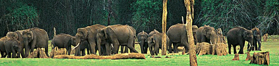
The Periyar Wildlife Sanctuary (Thekkady):
The most renowned destination is the Periyar Wildlife Sanctuary at
Thekkady, 60 km from Idukki, 190 km from Kochi or 114 km from Kottayam. The drive itself is enchanting as the road winds through tranquil countryside, rich plantations and thick jungles. The sanctuary is centred around the large (24 sq km) artificial lake formed by the dam across the Periyar river. Situated in a mountainous area, the highest peak in the sanctuary is Vellimala (2019 m). The sanctuary's 777 sq km of luxuriant green, rain-drenched tropical forest is the natural habitat of elephants,
bisons, spotted and sambar deer and wild boar, among other animals. Birds like the Malabar grey hornbill, the grey jungle fowl and the jungle myna can also be
spotted here. Tigers also inhabit the sanctuary which was declared a tiger reserve in 1978 under Project Tiger. But they are elusive and difficult to spot. Periyar is easily the best sanctuary in India for observing and photographing elephants at close quarters. On the boat cruise, if you're lucky, you will spot a herd or two in search of water at the edge of the lake. But for a truly memorable jungle experience, you should stay for a couple of days, preferably in one of the Forest Department's huts inside the sanctuary. At Thekkady there are opportunities for trekking, elephant rides and boating. This is especially popular as the boat navigates through the branched tops of trees submerged long ago by the man-made lake. Though the sanctuary is open throughout the year (the monsoons can bring a totally different experience), the best season is from September to May.
Munnar:
Munnar is situated at the confluence of three mountain streams -
Mudrapuzha, Nallathanni, Kundala. 1600 m. above sea level, this hill station was the summer resort of the British Government in South India. Sprawling tea plantations, picture book towns, winding lanes, and holiday facilities make this a popular hill station.
Among the exotic flora found in the forests and grasslands here is the
Neelakurinji. This flower which bathes the hills in blue once every twelve years, will bloom next in 2006 AD. Munnar also has the highest peak in South India, Anamudi - which towers over 2695 m. Anamudi is an ideal spot for trekking.
Tea Factory Visit: Permission to visit any of the 26 factories of Tata Tea Ltd. can be had from the Regional Office at
Munnar.
Eravikulam National Park:
While at Munnar, a not-to-be missed excursion is the the Eravikulam National Park, at the crest of the Anamala range. It can be reached only by trekking from
Rajamalai, 17 km from Munnar. In its 97 sq km area can be found the Nilgiri
tahr, and endangered species.
Mattupetty:
Beyond the dam, is the Indo-Swiss Dairy Farm, worth visiting not just to see prized cows and bulls but to savour the rolling green valleys.
Devikulam:
Another hill station woth visiting, 16 km south-west of
Munnar, is Devikulam, which literally means 'the lake of the Goddess'. According to legend,
Sita, the consort of Lord Rama, once had a bath in this lake.
Thommankuthu waterfalls:
18 km from Thodupuzha, is a scenic and bewitching picnic spot.
Peermede:
The best place to halt enroute is Peermede, 43 km before
Thekkady, a fertile land at an altitude of 914 metres. . Surrounded by rolling hills and valleys, Peerumed is well known for its waterfalls, open grasslands and delightful trekking trails. Formerly the summer palace of the Travancore Rajas, this tiny and cool hill station is full of rubber, tea, coffee, pepper and cardamom plantations, interspersed with waterfalls and open grasslands.
|